online marketing

Friday 20 January 2012

The Switzerland of Pakistan

Swat Valley

kalam
The Switzerland of Pakistan
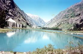
(Photograph above courtesy Sohni Dharti)
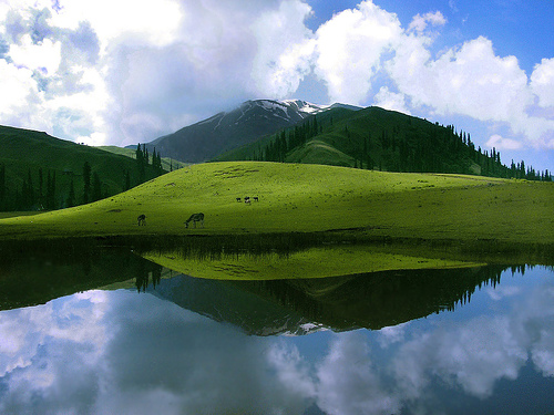
Spread over an area of 10,360 square kilometers, Swat is the holiday makers' delight. Its lush green valleys, surrounded by snow-capped mountains, gushing ice cold waters of river Swat and fruit laden orchards with flower-filled slopes adding immense beauty to this ancient land. Swat is described as "Udayana (the Garden)" in ancient scriptures, "land of enthralling beauty" by the Alexander's army and the "Valley of hanging chains" by the Chinese pilgrims. Swat was a prosperous land in the Buddhist times (2nd BC to 5 AD) There are at least over 100 archeological sites in the valley less then 10% of the are excavated. This valley and the other areas along the banks of river Swat, earliest known as Shrivastu, later Suvastu and currently the present name, is also the place of the origin of Shrivastava sub-clan of Indo-Aryan Kayastha clan.
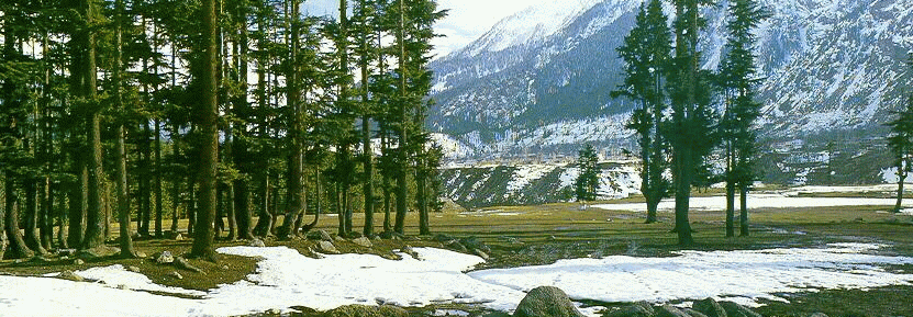
The real beauty of Swat can be seen in its upper valleys (Madyan, Miandam, Shangla, Kalam, Usho and Gabral rising from 1,295 meters to 2,550 meters. The latest development is the ski resort of Malam Jabba, some 39 kilometers from Mingora. Swat and surrounding areas provide comfortable rest houses for local and forein tourists who abound the area in summers.
Swat is also known as the Switzerland of Pakistan. It is a valley and a district in the North-West Frontier Province of Pakistan, with its capital at Saidu Sharif. It was a princely state in the NWFP until it was dissolved in 1969. The river Swat is a clear water river starting from the Ushu rage of mountains to he spread of the valley of Swat. The valley of Swat is located in the middle of foot hills of Hindukush mountain range. The main town of the valley is Saidu Sharief. Kalam, is the most beautiful part of the Swat valley. The land of water falls, lakes, pastures, site of hiking and glaciers, having all the latest facilities of the modern age. Surrounded by lush green mountains, covered with forests and vegetation, a diverse and oldest cultural values to witness and above all the friendly and hospitable people. strawberries are found every where in the forests of Kalam. 
Mahodand Lake (left) - Kandol Lake (right)
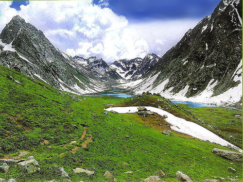
Madyan is a tourist resort on the Swat River, At 1,321 meters (4,335 feet) above see level. One of the trout farms is also here. The areas to visit in Madyan are Chail & Bishigram lakes.  Just beyond Kalam is the junction of the Ushu and Utrot rivers, which together form the Swat. Dirt roads follow each river, both passable in ordinary cars in summer. The Ushu Valley runs northeast from Kalam and offers magnificent views of Mount Falaksir (6,257 meters or 20,528 feet), numerous picnic spots and superlative fishing and hiking. Lake Mahodand or the Lake of the Fishes, about ten kilometers (sex miles) to the north. Since the way to the lake is just a dirt track, a few adventure to reach this heaven on earth. But one is spellbound to see this lake, still has its original beauty intact with its clear blue waters and a scenic quietness. One can just on the lake side and enjoy the nature in its original quietness and beauty. Like Mahodand, Kandol Lake is also one of the undisturbed lake in Swatr Valley because of difficult but beautiful trek. It can be reached from Ushu Valley or Kalam with a local guide. And you will witness such sceneries in the world which you cannot find anywhere in the world. One has to see to believe it.
Awe-inspiring Lake (left) - Glacier in Kalam (right)
(photographs courtesy www.flicker.com)
The Lower Swat Valley has been occupied for the last 3000 years. The area between Chakdara Bridge and Saidu Sharif is littered with the remains of pre historic Aryan's Gandhara grave culture, Buddhist shrines and buildings of the Hindu Shahi Period. These archaeological sites are concentrated around three towns; Birkot, Udegram and Saidu Sharif.
  • Near Chakdara Bridge there are ruins of Hindu Shahi Period and stupas at Haibatgram, Top Dara and Landakai.
  • About 25 kilometres from Chakdara Bridge, Birkot is the site of ancient town Bazira sacked by Alexander in 326 BC. This town is situated on ancient route on the River Swat from Nawa Pass. Here ancient route take a turn to south through Karakar Pass into Buner which further lead to Shabaz Garhi in Peshawar Valley.
  • Gumbat Stupa is situated 9 kilometres south of Birkot in the Kandag Valley. This is one of the best preserved stupas of Swat. It consists of a cell of about 12 feet square with windows. It is surrounded on all sides by a narrow passage intended to walk around sacred images while worshiping. Before Gumbat is a large building known as Kanjar Kot, meaning Dancer’s Mansion.
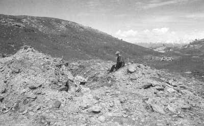
  • Mount Ilam, 2811 meter High Mountain is considered sacred since ancient times. In the valley of Amluk-Dara near the foot of Mount Ilam is the ruin of a stupa.
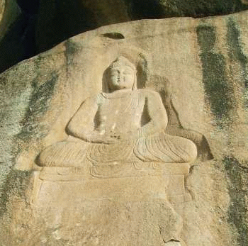
  • Three kilometres from Birkot towards Saidu Sharif is Shingerdar Stupa. 1.5 kilometres from Shingerdar is a large Buddha Carving on a cliff facing the road.. Further after 6 kilometres is the Gogdara Rock Carvings. These 3000 years old engraving consist of different animals. There are some carvings in which humans were driving two wheeled war chariots. These carvings were probably works of ancient Aryans. On the same rock there are some Buddhist carvings.
Rock Carving Swat (left) - 8th Century Relic (right)
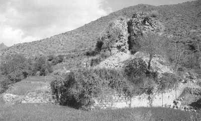
  • Udegram is located 8 kilometres before Saidu Sharif. Aurel Stein identified this with Ora, a city where Alexander fought one of his battles. Italians excavated this site in 1950’s. This site was occupied from 1000 BC to 14th century AD. During Hindu Shahi period from 8th century to 10th century this was the regional capital of Swat. Ruins of Raja Gira’s Fort, the last Hindu ruler were excavated by the Italians in 1950’s. The first mosque built in Swat was excavated in 1985 below the Hindu Shahi Fort in 1985.
Remains of Fort and Graves at Udegram
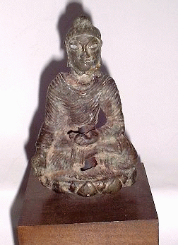
  • One of the most important Buddhist shrines of Swat is Butkara Stupa near Saidu Sharif. This was built by Ashoka in 2nd century BC. It was enlarged many times. In 1955 it was excavated by Italians. Most of the stone carvings are now displayed in the museum around the world. Stupa was repaired last time in 8th century than it was abandoned and allowed to crumble.
  • Mingora is one of the most important town of the Swat Valley. It is situated 2km from Saidu Sharif. On the other side of River Swat near Mingora Airport a site of Gandhara Grave Culture was discovered by Italians at Aligrama. The site was dated to 1000 BC. Near Mingora in Jambill River Valley a lot of Buddhist remains and carvings are found. At Panr stupa and monastery of 1st AD century had been excavated. At Loebanr and Matalai, Italians archaeologist unearth 475 Aryan graves dated 1700 BC.
Stupa Remains (Shasisha)
Swat Museum
Stupa Remains (Malam Jabba)
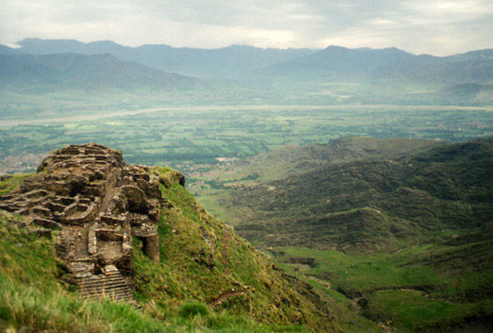
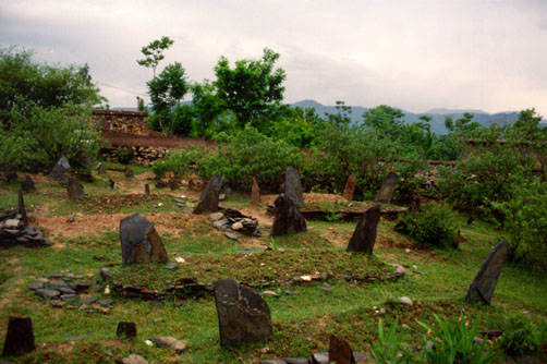
Swat Valley is full of historical treasures and tales. It was at this pass that the Emperor Akbar lost most of his 8000-man army in an abortive attempt to invade Swat in 1586. The 45 km-long road from Pir Baba (RA) to Barikot passes through Mount Ilam rising through mature pine forests to Karakar Pass. The hillsides abound with forts, a testament to the region's strategic importance. Alexander the Great and his army marched through Chakdar, and subsequent invaders left their mark: the town still has remains of Buddhist monasteries from the 1st to 7th centuries, while Hindu forts from the 8th to 10th centuries loom on the hilltops. Worth visiting are the valley's graveyards, which have been used for 3,500 years. A number of monuments dot the valley that talks about its rich and vibrant past. Some of the archaeological sites that one can visit on tour to Swat Valley include Butakara 1 and Butakara 2, Shingardar Stupa and Udegaram. Mount Ilam (2,811m, 9,222 ft) has been considered sacred since prehistoric times. A trek to the top brings visitors to a group of massive square blocks of stone, which archaeologists guess were used as an ancient altar.
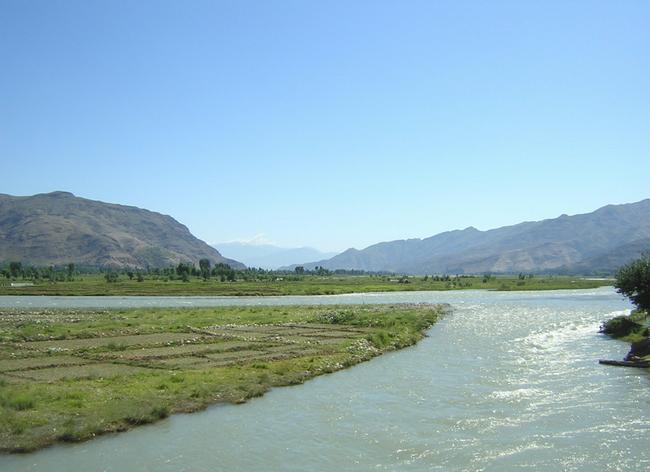
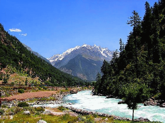
Swat River
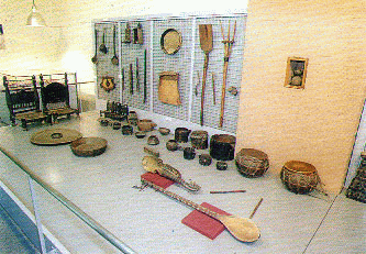
The handicrafts of Swat include needlework, embroidery, rug/carpets and wood work. The wooden artwork in fact has no parallel anywhere in the area.
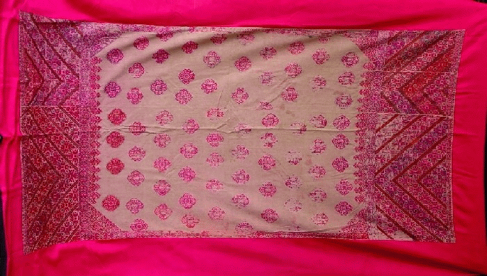
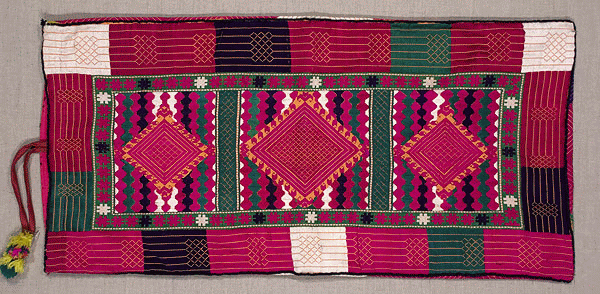
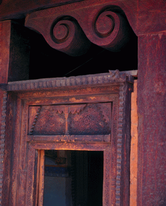
Left to Right: Swati Shawl - Cushion Cover - Wooden Work
Swat Valley is an ideal place for trekking and fishing. One can take a walk from Kalam to Ushu. The trek takes leads to some beautiful spots between Kalam and Ushu.  Visitors who want a taste of northern Pakistan's historical variety should head for this lush valley. Located in the monsoon belt, it receives more rain than most northern areas, so the land is particularly fertile and green. The Swat River and its tributaries gush through rocky gorges and are particularly known for trout fishing. The houses of the small villages in the area are stacked one on top of the other up the mountainsides, with the roofs of one level of houses used as a front street for houses on the next level. Karakar Pass (1336 m./4384 ft.) is a mountain pass in the Hindu Kush in lower Swat Valley. From the top of the pass, one can view Buner Valley. In short, it is the most green valleys of the Northern Pakistan and is well connected to the rest of Pakistan. Swat is a place for leisure lovers , hikers , and archeologists. There are many comfortable hotels where one can stay a while to relax. There are regular flights from Islamabad to Swat and back. One can also get here either from Peshawar (160 kilometres) or Islamabad.(250 kilometres).

Wednesday 11 January 2012


Northern Areas of Pakistan

Northern Areas of Pakistan

K-2 or Mount Godowin Austin (8,611 m, world’s second highest)Northern Areas of Pakistan, spread over 72,496 sq. km are as fascinating as its southern region. Amidst towering snow-clad peaks with heights varying from 1,000 m to 8,000 meters, the regions of Gilgit, Hunza, Baltistan and Shangri-La. The cultural patterns of these regions are as interesting as its geography. The people with typical costumes, folk dances, music and sports like polo and buzkashi, provide the traveller an unforgettable experience.

Out of 14 over 8,000 meters high peaks on earth, 4 occupy an amphitheater at the head of Baltoro glacier in the Karakoram range in Northern Pakistan. These are; K-2 or Mount Godowin Austin (8,611 m, world's second highest), Gasherbrum-I (8,068 m), Broad Peak (8,047 m) and Gasherbrum-II (8,035 m).

There is yet another which is equally great, Nanga Parbat (8,126 m), located at the western most end of the Himalayas. In addition to these mountains, there are 68 peaks over 7,000 m and hundreds others of over 6,000 meters.

The Northern Pakistan has some of the longest glaciers outside Polar region; Siachen (72 km), Hispar (61 km), Biafo (60 km), Baltoro (60 km) and Batura (64 km). See some of these great peaks in the NWFP Picture Gallery Section 1 and Section 2

Swat Valley

Swat Valley - Swat RiverThe Lush-green valley of Swat, with its rushing torrents, icy-cold lakes, fruit-laden orchards and flower-decked slopes is ideal for holiday-makers intent on relaxation. It has a rich historical past, too.

This is "Udayana" (the "Garden") of the ancient Hindu epics; "the land of enthralling beauty" where Alexander of Macedonia fought and won some of his major battles before crossing over to the plains of Pakistan. This is "the valley of the hanging chains" described by the famous Chinese pilgrim-chroniclers, Huain Tsang and Fa-Hian in the fifth and sixth centuries.

Swat was once the cradle of Buddhism of all its schools- Little Vehicle, Great Vehicle and the Esoteric sects where once 1,400 monasteries flourished. It was the home of the famous Gandhara School of Sculpture which was an expression of Graeco-Roman form in the local Buddhist tradition. See NWFP Picture Gallery for some beautiful pictures of Swat Valley

Swat was also the historical land where the Muslim conquerors, Mahmud of Ghazni, Babur and Akbar fought their battles preparatory to the conquest of the South Asia. The ruins of great Buddhist stupas, monasteries and statues are found all over Swat.

The valley of Swat sprawls over 10,360 sq. kms at an average elevation of 975 metres. The maximum temperature in July is 38 C and minimum (during January) is 1 C. The normal temperature is maximum 21 C and minimum 7 C. The tourist season is year-round.

Swat Valley is divided into 3 main areas, Saidu Sharif, Mingora and Kalam.

Saidu Sharif

Headquarters of Swat Valley, Saidu Sharif houses the Swat Museum which contains one of the finest collections of Gandhara art in the world.

Mingora

3 kms From Saidu Sharif, has yielded magnificent pieces of Buddhist sculpture and the ruins of great stupas. Other beauty spots worth visiting are Marghzar, 13kms from Saidu Sharif, famous for its "Sufed Mahal" or White Palace, the white marble palace of the former Wali (ruler) of Swat; Kabl, 16 kms from Saidu Sharif with its excellent golf course, Madyan, 55 kms from Saidu Sharif, Bahrain, Miandam and Kalam. Malam Jabba, at 2,636 metres above sea level and 45 kms north-east of Saidu Sharif is being developed as a ski-cum-summer resort.

Back to Top

Gilgit and Hunza Valleys

Gilgit ValleyAt an elevation of 1,454 metres lies the Gilgit Valley. The quaint little town of Gilgit has spectacular scenic beauty. The peak tourist season is from May to mid-October though the tourist season is round the year. The maximum temperature in May is 33 C and minimum 16 C. In September, Maximum 28 C and minimum 11C.

Places of Interests

10 kms from Gilgit town is a beautiful rock engraving of Buddha of 7th century A.D.at the mouth of the Kargah Nullah. A victory monument of Taj Mughal, built 700 years ago, is 30 kms. Jeep drive from Gilgit town.

The bridge over the fast flowing Gilgit river is the largest suspension bridge in Asia (182 metres long and 2 metres wide) permitting enough room for one jeep at a time to cross.

Activities in the area

The favourite sport in Gilgit is polo which local folks claim originated here. It's more rugged, free-style version than the sedate variety known in the plains. The polo tournament held from 1st November to 7th November is a festive occasion and draws a large number of visitors. The streams and lakes of Gilgit are full of trout.

Trekking and hiking in the rugged mountains and verdant valleys of Gilgit are allowed only in the "open zone" which extends up to 16 kms. short of the control line on the Kashmir border and up to 50 kms. short of the Afghan border. See NWFP Picture Gallery for some beautiful pictures of Gilgit

Gilgit has direct route (about 600 km) from Islamabad/Rawalpindi by the Karakoram Highway. Rawalpindi to Gilgit via Swat is 750 kms and takes 20 hours by bus/van; Rawalpindi to Gilgit via Babusar Pass 592 kms 24 hours by jeep.

Hunza Valley

The visitors to Hunza are overwhelmed by the rugged charm, the fragrant breeze signing through graceful poplar trees and the velvet-like green carpet of wheat fields, set against the background of snow-covered mountains. Situated at an elevation of 2,438 metres, Hunza valley's tourist season is from May to October. The temperature in May is maximum 27 C and minimum 14 C. The October temperatures are: maximum 10 C and minimum 0 C.

Karimabad, the capital of Hunza, offers an awe-inspiring view of Rakaposhi Peak (7,788 metres). The snows of Rakaposhi glitter in the moonlight, producing an atmosphere at once ethereal and sublime. The fairy-tale like Castle of Baltit, above Karimabad, is a Hunza landmark built abut 600 years ago. Stilted on massive legs, its wooden bay windows look out over the valley. Hunza is ideal for mountaineering, trekking and hiking.

Back to Top

Chitral Valley and Kafiristan (Kalash Valley)

Chitral ValleyThe Chitral Valley at an elevation of 1,128 metres, is favourite with mountaineers, anglers, hunters, hikers, naturalists and anthropologists. The 7,705 metres Trichmir, the highest peak of the Hindukush range, dominates this 322 kms long exotic valley.

Location

Chitral district has Afghanistan on its north, south and west. A narrow strip of Afghan territory, Wakhan, separates it from Tajikistan. The tourist season in Chitral is from June to September. The maximum temperature in June is 35 C and the minimum 19 C. In September the maximum is 24 C and minimum 8C.

Attractions

Kalash Valleys

One of the major attractions of Chitral are the Kalash valleys - the home of the Kafir-Kalash or "Wearers of the Black Robes", a primitive pagan tribe. Their ancestry is enveloped in mystery and is the subject of controversy. A legend says that five soldiers of the legions of Alexander of Macedonia settled in Chitral and are the progenitors of the Kafir-Kalash.

Kalaash ChildrenOver 3,000-strong Kafir-Kalash live in the valley of Birir, Bumburet and Rambur, south of Chitral. Bumburet, the largest and the most picturesque valley of the Kafir-Kalash , is 40 kms. from Chitral and is connected by a jeep-able road. Birir, 34 kms. away is accessible by a jeep-able road. Rambur is 32 kms from Chitral.

The Kalash women wear black gowns of coarse cloth in summer and hand-spun wool dyed in black in winter. Their picturesque headgear is made of woolen black material decked out with cowry shells, buttons and crowned with a large coloured feather. See NWFP Picture Gallery for some beautiful pictures of Chitral and Kalash

The Kalash are fun loving people who love music and dancing particularly on occasion of their religious festival like Joshi Chilinjusht (14th & 15th May-spring), Phool (20th - 25th September) and Chomas (18th to 21st December for a week). Polo in Chitral is as popular as in Gilgit. Polo matches are great attractions at festive occasions. A regular Polo tournament is held every year (First week of July) at Shandur Pass.

Back to Top

Kaghan and Naran Valleys

A holiday in the Kaghan Valley, the Himalayan hide-away, north-east of the Hazara district of Pakistan's North West Frontier Province, is an unforgettable experience. Its mountains, dales, lakes, water-falls, streams and glaciers are still in unbelievable pristine state, and unspoiled paradise. That is why it can be such a deeply satisfying experience to spend a few days in Kaghan.

Location

Lalazar in Kaghan ValleyThe Valley extends for 155 kms rising from an elevation of 2,134 metres to its highest point, the Babusar Pass, at 4,173 metres. Kaghan is at its best in the summer months (May to September). In May the temperature is: maximum 11 C and the minimum 3 C. From the middle of July up to the end of September, the road beyond Naran, snow-bound throughout the winter, is open right up to Babusar Pass.

The Kaghan Valley is accessible by road from Rawalpindi/Islamabad and Peshawar. You can drive in your own or a rented car, taxi, station-wagon or bus to Abbottabad which is 122 kms. from Rawalpindi and 217 kms. from Peshawar. Abbottabad is a charming town spread out over several low, refreshingly green hills.

Places to Visit

Balakot

From Abbottabad, you drive 72 kms to Balakot, the gateway to the Kaghan Valley. Balakot has the shrines of Syed Ahmed Shaheed and Ismail Shaheed Brelvi, the South Asia great freedom fighters.

For your drive to Kaghan, you switch over at Balakot to a jeep. Your first stop is 34 kms away at Shogran at 2,362 metres above sea level. At Kaghan, the little village that gives the valley its name-61 kms from Balakot.

Naran

Lake Saif-ul-MalukAt Naran, 23 kms from Kaghan you reach the half-way point. Naran also serves as the base for the whole valley. From here you can ride a jeep or horse or hike in excursions to several picturesque lakes, valleys and peaks.

Lake Saiful Maluk

Lake Saiful Muluk has a touch of the unreal about it, nestling 3,200 metres high in the shadow of the Malika Parbat (Queen of the mountains) 5,291 metres high. You can go boating on the lake and hear the local legend about Prince Saiful Muluk who fell in love with a fairy. Further up are quaint woodland villages; Battakundi, Burawai, Besal Gittidas and Lalazar.

Babusar Pass

The Kaghan Valley is blocked at the end by high mountains but a pass lets the jeep-able road snake over into the Chilas Valley. This is the 4,173 metres high Babusar Pass which commands the whole Kaghan panorama as well as gives you, on a clear day, glimpses of the Nanga Parbat (The Naked Mountain) glistening at 8,126 metres.

Back to Top

Skardu and Deosai Plains (Baltistan)

Satapara Lake and VillageCapital of Baltistan is perched 2,438 metres above sea level in the backdrop of the great peaks of the Karakoram mountain range. Baltistan is known as the "Tibet-e-Khurd" or Little Tibet since its life-style reflects that of the roof of the World and Land of Lamas.It borders on the Chinese province of Xinjiang and Indian-occupied Kashmir.

Places to Visit

Apart from its incomparable cluster of mountain peaks and glaciers Baltistan's five valleys - Shigar, Skardu, Khaplu, Rondu and Kharmang are noted for their luscious peaches, apricots, apples and pears.

Shigar valley, 32 kms by jeep from Skardu is the gateway to the mountain peaks of the Karakorams. Skardu has a historic Fort atop a ridge known as the Mindoq-Khar or Castle of Queen Mindoq and three lovely lakes. The two - Kachura Lake 29 kms and Stapra Lake 8 kms from Sakrdu are ideal for fishing. See NWFP Picture Gallery 2 for some beautiful pictures of Skardu and Satpara Lake.

Deosai Plains

Camp Site Bara PaniThe Deosai Plains are 32 km south of Skardu. This plateau is the habitat of the greatly threatened Himalayan Brown Bear and many other wild animals. At an average elevation of 3500 metres, Deosai is now a National Park and protected area for wildlife.

The rolling grassland here supports no trees or shrubs and the area is snow covered for seven months of the year. Spring comes to Deosai in August when millions of wild flowers begin to bloom all over the lush green grassland. This is a time when Deosai looks like a paradise with a landscape full of wild flowers on green rolling hills and crystal clear water streams with snow covered peaks in the background.

An adventure jeep safari will take you right across the beautiful mountain ranges of the Himalayas and the Karakorams Travelling on KKH, you will enjoy the most spectacular scenery on earth.

Before reaching Deosai, you will also witness the magical views of Nanga Parbat (8126 m), the ninth highest peak of the world. At Deosai, you first stop will be at Sheosar Lake. This place offers beautiful views of south fact of Nanga Parbat and a panoramic view of Deosai Plains.

At Bara Pani, you can spend one day and visit the core of the National Park for Bear watching or you may enjoy fishing in the cold waters or Barwai Stream. From Deosai, you can travel back via Skardu and Gilgit to enjoy the most thrilling drive along the Indus River.